Luxury Travel
Luxury Travel

Super User
Email: This email address is being protected from spambots. You need JavaScript enabled to view it.
Monday, 07 September 2020 00:00
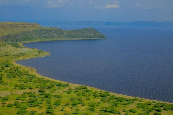
Alatish National Park
Alatish is a newly established national park that is located in Quara woreda of Northern Gondar Zone. It was established in 2006 and derives its name from the Alatish River that has its source in the park and flows in a westerly direction to the Sudan. The park shares its boundaries in the south with Benishangul - Gumuz Regional State, in the west with the Sudan, in the east with Bembaho Kebele, in the northeast with Gelego Kebele and in the north with Mahdid Kebele.
It covers an area of 266,570 ha composed of lowland woodlands. Landscape at Alatish is flat with elevation ranging from 520 to 920 meter above sea level. There are a few hills in the eastern and north-eastern parts of the area. The twin mountains of Amdog are a special feature in the southwestern corner of the park. The soils of Alatish are composed of sandand gravel. Some sections of the area have bedrocks that impede the infiltration of water into the aquifer. These areas provide suitable habitat for seasonal wetlands, which in turn are productive habitats for birds, fish and other wildlife.
Agro-ecologically, the park is classified as dry kola with annual rainfall ranging between 500-1500 mm. The boundaries of the park were defined in 1998 but were redefined with the participation of local communities in 2004. The vegetation of the park is classified asCombretum-Terminalia broad-leaved deciduous woodland. Dominant grass species include Cymbopogon spp., Hyperhenia filipendula, Echinochloa sp, Pennisetum spp. There are 26 larger mammals (excluding rodents) and 143 recorded bird species. The ornithology of the area requires more investigation but estimates based on habitat diversity show that there could by anything between 250-400 species of birds representing various status. Alatish is found in an arid and semi-arid ecological zone. It forms an ecotone between the high mountains of the Simen and the Sahel zone in the Sudan. As a result, the biological attributes of the park are believed to be diverse and rich. Alatish also has a number ofhistorical and cultural assets. Of these, a large Baobab tree at Omedla and the ethnic composition of the area made up of Felata and Gumuz communities are important tourist attractions.
Unique features - This area has recently been set aside as a national park by the Amhara Region. The park is believed to conserve a major proportion of Sahelian and Sudan-Guinea biome birds and other organisms. It serves as a migratory route for Elephants, which traverse from Dinder National Park in the Sudan. As a result, its role is significant in the formation of a transboundary park between Ethiopia and neighbouring Sudan. The various rivers that drain into Sudan from Alatish are important tributaries of the Nile.
Published in
National Parks
Tagged under
Monday, 07 September 2020 00:00
Kafta-Shiraro Wildlife Park
Kafta-Shiraro is located in western Tigray, With its 500,000 ha area, it is one of the largest conservation areas in Ethiopia. It is bordered by Eritrea in the north, Shiraro in the east, Wolkaite in the south and Humera in the west. Within Tigray it is positioned in the woredas of Kafta-Humera and Tahtay-Adiabo. While the main river is the Tackazee, it is fed by a number of riverst that orginate in the Simen Mountains and highlands of Wolkait. Elevation ranges from 550 masl on the edge of Tackaze River 1800 masl on the highlands of Kafta. The agro-climatic zone is identified as Qolla with an inclination to semi-arid. Vegetation communities within the reserve include Acacia-Commiphora,combretum-Terminalia, dry evergreen montane woodlands and riparian types. The site has a mono-modal pattern of rain with high peaks in May and early September. Preliminary records show that the site conserves 42 mammalian and 95 avian species. Major wildlife conserved include Ostrich, Aardvark, Elephant, Greater kudu, Roan Antelope, Red-fronted Gazelle, Caracal, Leopard and Lion.
Unique features - The reserve is important for the conservation of Elephants. It is one of nine sites in Ethiopia that conserve Elephants. The Elephant population in Kafta migrates seasonally between Ethiopia and Eritrea. At present the site is known to hold an estimated 100-150 individual Elephants. Besides Elephants, it conserves 42 mammals 167 birds and 9 reptile species. The site is extremely important and could well be the only site in the country for wintering Demoiselle Crane. A recent discovery shows that the northwestern border of the park holds more than 20,000 Demoiselle Cranes.
Published in
National Parks
Tagged under
Monday, 07 September 2020 00:00
Maze National Park
Maze National Park is a recently established National Park in the Region. The park derives it name after Maze River that traverses through its length. It was established in 2003 after several surveys and studies were carried out. Prior to 2003, Maze served as a hunting area for Swayne‟s Hartebeest and Buffalo. It is a small park with an area of 2,020 ha and located 473 and 248 kms from Addis Ababa and Awassa respectively. Altitude ranges from 1000 to 1200 meter above sea level. The rainy season extends from March to September and rain is estimated to be between 800 to 1600 mm per annum. While the area has 38 species of mammals, major wildlife includes Swayne‟s Hartebeest and Buffalo. To date, 138 bird species have been recorded for Maze.
Unique features - Maze is one of the last remaining sites for the conservation of the Swayne‟s Hartebeest. It is arguably the second most important site for the Swayne‟s Hartebeest after Senkelle Hartebeest Sanctuary. Recent wildlife counts have revealed there could be up to 300 Hartebeests at Maze. Besides wildlife the site has unique land features. Mt Gughe, which rises to 4200 meter above sea level is found on the boundary of the park. Bilbo hot springs, found in the Park‟s southern parts, have geysers that spout steam into the air. The Wonja caves are an added attraction to the site.
Published in
National Parks
Tagged under
Monday, 07 September 2020 00:00
Gambella National PARK
The Gambella National Park was created for the numerous larger wildlife species representative of the neighboring Sudan, particularly Nile Lechewe, White-eard Kob and White-headed stork; in addition to extensive areas of swamp habitat.
Location: the park is situated in Gambella region, some 800km West of Addis Ababa at the coordinate between N8000’ and E34015’. The altitude of the park ranges between 400-768 asl. It is located close to the Sudan border.
Rainy season: the area receives greatest amount of rainfall that averages about 1,400mm per year. The rainy season tends from April to October. The main dry season is November to March.
Temperature: the highest temperatures are 36-400c in November to March.
Ecological zone: west Ethiopia
Vegetation type: Savanna characteristics predominantly swamp deciduous woodland and riparian formations.
Major wildlife species: include Roan Antelope, White_eard Kob, Nile Lechwe,, Topi, Buffalo, Elephant, Lelwel Hartebeest, Waterbuck, Giraffe, Hippopotamus, Crocodile, Lion and Leopard.
Major physical/geological features: extensiv swamps and wetlands
Published in
National Parks
Tagged under
Monday, 07 September 2020 00:00
Food tour
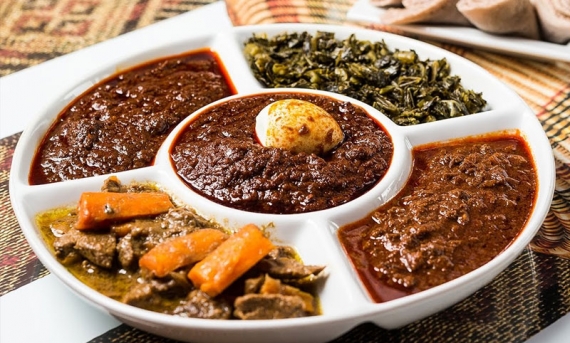
Addis Ababa Culinary Tours combines the best of Ethiopia’s Diverse history, food, and drinks with unique historic tours that highlight local cuisine and cocktails.
Each Addis Ababa Culinary Tour visits several different restaurants, bars, and the Farmer’s Market to combine elements of a historical tour with a culinary or drink adventure! The food and cocktails on your tour are chosen by our restaurant and bar partners featuring an array of eclectic dishes and concoctions that provide insight into Addis Ababa cuisine and cocktail scene. On each food tour, you not only have an opportunity to sample some of the Lowcountry’s finest food offerings, but also to meet the owners, chefs, and mixologists behind Addis Ababa impressive culinary and bar innovations.
As most walking food tours sell out, all reservations are required in advance. Each tour is limited in size, so it is recommended that you get your reservations early. Addis Ababa Culinary Tours are held rain or shine, come to Ethiopia and let’s show you Ethiopia’s Unique Authentic Culinary Experience.
Published in
Food Tour Ethiopian Culinary experience
Tagged under
Monday, 07 September 2020 00:00
Hot Air Balloon

For consumers
We organizes several services for consumers like combined balloon flights, private balloon flights and special packages
For companies
We offers several services for companies and organisations like private balloon flights, branded hot air balloons and basket branding specials
Flight schedule
Every week we organise several magical sunrise balloon flights.
Published in
Hot Air Ballon Tour
Tagged under
Monday, 07 September 2020 00:00
Yangudi Rassa National Park
The park was especially created to secure a protected desert ecosystem for wild Ass, along with the consideration of its geological and archeological significances. Its’ Value being a refuge and a route to palearctic and Intra Africa migratory birds is of a great concern too. Species recorded: 36 mammals and 230 birds Charismatic species: Walia Ibex Location: the park is located on the north eastern part of the country between N10045’latitude and E40045’ longitude. The head Quarter is situated in Gewane, Afar region, some 365km from Addis Ababa on Djibouti road. The altitude of the park ranges between 400-1460m asl. Rainy season: as the area is arid usually experiences an erratic and how rainfall pattern, ranging between 200 and 400mm. the rainfall distribution follows bimodal pattern, in which small showers occurs from February through March and Second rainy season usually July to August Temperature: Maximum reading usually fluctuates over 420c
Ecological Zone: Rift valley Vegetation type: semi desert trees and succulent scrub, semi arid grass and plains shrub-steppe, bushland and acacia wooded grassland. Major wildlife species: wild Ass, Soemmerring’s Gazelle, Hamadryas Baboon, Gerenuk, Cheetah, leopard, Lion, Greater Kudu, Lasser Kudu, Salt’s Dikdik and Warthogs. Major physical geological features: Awash Rivr, active volcanoes, archeological sites extensive arid desert ecosystem, nearby alkaline lakes and Dallol Depression. Attractions: Hundufo plain for game viewing, Awash reverine forest for bird watching and Yangudi Mountain Outside parks: Gewane, Mile Sardo and Alledeghi reserves offer good opportunity to view a spectacular number of games, including Soemmerring Gazelle, Beisa Oryx, Wild Ass, Gerenuk, Ostrich, Dorcas Gazzelle and Grevey’s Zebra More to discover the surrounding beauties: Hadar archeological site, active volcano around Afders, Dallol depression, Artale, Alkaline Lakes
Published in
National Parks
Tagged under
Monday, 07 September 2020 00:00
Geraille NATIONAL PARK'
Geraille national park ( also called gerale national park ) is a new park and it lies in liben zone in the southewest part of the somali national region state in liben zone. it is located in the estern part of moyale woreda .it is about 900 km southe east of addis ababa and 120 km north of moyale . The park cover around 38,580 ha of the total 104,230 ha of the area of the dawa ecosystem .
The area encompasses what used to be previously known as the Borana Controlled Hunting Area in Southern Ethiopia. The Park was proposed to conserve various savannah wildlife including rare animals like, Giraffe, African Elephant and even the Black Rhinoceros. Although local people claim to have seen the latter visits to the area have proved otherwise.
Gerale has low human population density but is relatively rich in wildlife resources. Altitude ranges from 800 meter above sea level on the banks if the Dawa River to 1380 masl on top of the escarpments. The Dawa River forms important surface water feature for this arid site. The Dawa forms its boundary on the eastern and northeastern side while the Day escarpment is found on the west. The villages of Karaya, Sororo, Gelgelu are located to the south and south east of the park. The whole area is found within a semi-arizd zone and is characterized by prolonged dry season lasting up to seven months. A bimodal rain pattern is apparent with peaks from September to November and from April To June. The mean annual rainfall for Moyale is 503 mm. The area is typically Somali-Masai and the dominant vegetation type is Acacia-Commiphora. Major woody plants include Acacia mellifera, A. brevispica, A. oerfata and various Commiphora spp. Habitats include grasslands, wodded grasslands, open shrubland, thickets, riparian woodlands and exposed sand/soils. At least 36 species of larger mammals have been identified including bats. Major wildlife conserved includes Beisa Oryx, Grant’s Gazelle, Gerenuk, Lesser Kudu, and Guenther’s Dikdik, Avifauna is rich as well and a provisional list for the area has 164 recorded species.
Vegetation - Mostly the vegetation composition is made up of small trees and shrubs, which are 3-4 m in height. The dominant species include Acacia mellifera, Acacia oerfata, Acacia brevispica and several species of Comifora species. The area is also characterized by grassland, open shrub land, dense shrub land, dense bush land, wooded grassland and riparian woodland/bush land. The dominant grass species include Ischamum species and Chrysopogon species. The area is generally rich in floral diversity as in the case of other parts of the Somali-Massai biome-East African evergreen vegetation type.
Unique features - This park was proposed by the Somali National Regional state, although it is now under the supervision of EWCA, to conserve unique assemblage of wildlife in the Somali-Massai Biome. This Biome covers large tracts of land in Ethiopia and the park is known to harbor few Elephants, Hunting Dog, Cheetah and Giraffe. It provides haven for several antelope species. The most prolific antelopes are Guenther’s Dikdik, Beisa Oryx, Grant’s Gazelles, Gerenuk and Lesser Kudu. Amongst birds, the endemic white-tailed Swallow has been recorded here. The site is found wholly within the Juba/Shebelle Endemic Bird Area. Restricted range species including the White-winged Dove and juba Weaver are residents. The area conserves not less than 50% of birds listed in the Somali-Masai Biome Assemblage.
Published in
National Parks
Tagged under
Monday, 07 September 2020 00:00
Abijatta-Shala
Abijatta-Shalla Lakes National Park was primarily created for its spectacular numbers of aquatic birds, especially Great white Pelican and Lesser Flamingo the bird breeding islands in Lake Shalla, and its scenery. It is a famous and significant ornithological site in the country.
Species recorded: 76 mammal species and 436 bird species
Charismatic species: White Pelican
Location: Abijatta-Shalla Lakes National Park is found 207 kms south of Addis, situated in the main Rift Valley it’s a park back grounds the two beautiful Rift Valley Lakes Abijata and Shalla. It is located on the co-ordinates 7030’N and 38030’E. The general area is within an altitude range of 1540-2075m asl.
Rainy season: The climate of the park is generally dry. Located in a rainfall deficit area of the Rift Valley, it eceives an annual rainfall range between 500 and 700mm during the two wet seasons, with the small rain periods are March to April and the main is June to September.
Temperature: the minimum and maximum temperature range between 50c and 450c respectively.
Ecological Zone: Rift Valley
Vegetation types: Acacia-Euphorbia woodlands savanna
Published in
National Parks
Tagged under

Contact Us
Our Address:
Office Address – Bole Medhanealem in front of beer garden Inn - Addis Ababa, Ethiopia
+ 251 930 099360
+ 251 911 171217
+ 251 935 403435
We Accept

